
Garmin GPSMAP 65s
4.6Editor score
Multi-band satellite support
2.6 inch color display
Routable topographic mapping
Finding the right handheld altimeter is crucial for outdoor enthusiasts who rely on precise elevation data. Whether you are hiking steep trails or monitoring weather patterns, a reliable device ensures safety and enhances your experience in the wild.
We evaluated ten distinct models based on accuracy, durability, and ease of use. Our analysis covers analog and digital options to help you understand which features matter most for your specific outdoor activities and environmental conditions.
Each product selection highlights key strengths and potential limitations to guide your decision. Remember that availability and pricing can fluctuate, so always check the latest details before finalizing your purchase for your next adventure.
4.6Editor score
4.3Editor score

5.0Editor score
As an Amazon Associate we earn from qualifying purchases.
This side-by-side comparison details the core capabilities of each selected device to help you quickly identify which model aligns with your outdoor requirements and performance expectations.


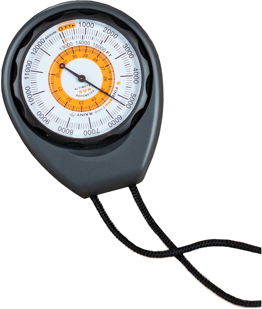
The Sun Company Altimeter 203 stands out as a reliable analog device for outdoor navigation. It receives strong ratings for its simplicity and rugged build quality which appeals to hikers avoiding digital complexity.
We may earn a commission when you buy through this link, at no additional cost to you.
Its battery-free design ensures it works indefinitely as long as you calibrate the dial. The adjustable mechanism accounts for local pressure changes so altitude readings remain accurate across different weather systems.
While it lacks electronic features it requires manual setup which can be tricky for beginners. However this trade-off is acceptable for users prioritizing reliability and longevity over advanced data tracking.
This model is ideal for casual hikers and campers who want a straightforward tool. We recommend it for anyone seeking a dependable analog altimeter that functions without power sources.
The device operates solely on barometric pressure changes ensuring it works without batteries or electronics that can fail in the field.
It includes a built-in trend indicator that helps predict incoming weather systems based on pressure shifts over time.
We may earn a commission when you buy through this link, at no additional cost to you.
The BTMETER BT-100WM offers extensive weather metrics beyond simple altitude. It excels in environments where wind speed and temperature are critical for safety or performance.
We may earn a commission when you buy through this link, at no additional cost to you.
Its data logging capability allows you to track changes over time which is useful for long trips. The backlit screen ensures visibility in low light conditions.
The interface may feel complicated for those wanting quick reads. Additionally reliance on batteries means you must carry spares for extended use.
Buy this if you need detailed atmospheric data alongside altitude. It suits serious outdoor enthusiasts and weather observers better than casual campers.
This unit measures wind speed, temperature, humidity, and dew point providing a full picture of local weather.
It stores up to sixteen groups of pressure data for later comparison and analysis during your outdoor sessions.
We may earn a commission when you buy through this link, at no additional cost to you.
This device integrates eight tools into one small package making it highly portable. It provides basic altitude and direction data suitable for light outdoor activities.
We may earn a commission when you buy through this link, at no additional cost to you.
The 8-in-1 layout saves space and weight in your pack. However its lower rating suggests accuracy and durability may vary compared to higher-end models.
Construction feels basic which may not withstand rough abuse. Users seeking high precision should look elsewhere but this works for occasional trips.
Choose this if budget and size are top priorities. It serves well for light hiking where extreme accuracy is not critical.
Combines compass thermometer and altimeter into one unit reducing the gear you need to carry on short trails.
A five-second backlight helps you check readings in dark conditions without needing an external light source.
We may earn a commission when you buy through this link, at no additional cost to you.
This model offers an impressive range for high-altitude expeditions. It covers nearly all typical hiking elevations making it versatile for mountain activities.
We may earn a commission when you buy through this link, at no additional cost to you.
The dual range support for altitude and pressure ensures compatibility across different measurement systems. Backlighting aids reading during early morning starts.
Build quality is average and may not resist heavy impacts. Users in harsh environments might find it less durable than rugged brands.
Select this for high-elevation adventures on a budget. It provides necessary data without the cost of professional-grade electronics.
Measures up to twenty nine thousand five hundred feet suitable for climbing and high-elevation trekking.
Supports mbar readings for global compatibility ensuring accurate tracking regardless of your region.
We may earn a commission when you buy through this link, at no additional cost to you.
The AltiLINQ is designed specifically for vehicles but works for hand held use too. It offers a clear view for drivers monitoring elevation changes on mountain roads.
We may earn a commission when you buy through this link, at no additional cost to you.
Mounting options allow flexible placement on dashboards. The analog mechanism ensures reliability without electrical dependency during travel.
It may lack ruggedness for heavy outdoor hiking compared to dedicated handhelds. The focus on vehicle mounting limits its primary application.
Ideal for drivers and road trippers who want elevation data. It serves well for car camping where easy access is key.
Two hook-and-loop attachments allow quick mounting on dashboards for easy monitoring during driving.
Despite being a dashboard unit it can be removed for brief use during stops on hiking trails.
We may earn a commission when you buy through this link, at no additional cost to you.
This device excels in forestry and surveying tasks needing precise slope and height data. Its high rating reflects reliability for professional field work.
We may earn a commission when you buy through this link, at no additional cost to you.
Waterproof construction ensures durability in wet conditions. The aluminum body resists damage making it suitable for rough terrain.
It requires skill to use the sighting lens effectively. Casual hikers might find it complex compared to digital altitude displays.
Best for professionals needing accurate height measurements. Use it for forestry tasks where standard altimeters fall short.
A dedicated deflection angle lens allows precise measurement of angles and heights for surveying.
Sealed construction protects internal components from moisture ensuring reliability in rainy environments.
We may earn a commission when you buy through this link, at no additional cost to you.
The GPSMAP 65s is a top-tier device offering professional navigation tools. It delivers exceptional accuracy through multi-band satellite support for challenging terrain.
We may earn a commission when you buy through this link, at no additional cost to you.
Large color maps and a built-in barometric altimeter provide precise location and elevation. Integration with apps allows easy trip planning.
Higher cost and charging requirements are drawbacks for analog users. The investment pays off for serious adventurers needing reliable tracking.
Choose this for high-stakes outdoor navigation. It suits mountaineers and explorers who need the best available technology.
Accesses multiple satellite systems for optimal accuracy in dense forests or urban canyons.
Large sunlight-readable screen shows detailed topo maps for comprehensive route planning.
We may earn a commission when you buy through this link, at no additional cost to you.
This device combines essential tools in a compact design perfect for quick checks. The built-in carabiner clip allows hands-free access on backpacks.
We may earn a commission when you buy through this link, at no additional cost to you.
Its ABS construction handles drops and bumps well. The weather forecast feature gives you advance warning of conditions ahead.
Lack of backlight limits night use. It focuses on core features making it accessible for budget-conscious buyers.
Ideal for budget-friendly outdoor prep. It works well for car trips and short hikes where basic data is sufficient.
Built-in hook attaches easily to backpacks for immediate access during outdoor activities.
Combines altimeter barometer and thermometer for essential monitoring without bulk.
We may earn a commission when you buy through this link, at no additional cost to you.
This pocket-sized device offers portability without sacrificing aluminum durability. It fits easily in pockets making it convenient for daily carry.
We may earn a commission when you buy through this link, at no additional cost to you.
The included fabric case provides protection during transport. Its waterproof design ensures it survives outdoor weather exposure.
The dial is small which can make reading difficult. Users with larger hands might struggle with precision.
Best for users prioritizing portability. It suits quick elevation checks where a full-size device is impractical.
Small dimensions allow easy pocket storage for spontaneous outdoor checks.
Soft fabric box protects the device from scratches during transport.
We may earn a commission when you buy through this link, at no additional cost to you.
This device integrates GPS with altitude tracking for sports monitoring. It supports multiple satellite systems for broader coverage.
We may earn a commission when you buy through this link, at no additional cost to you.
Height reminders allow setting personal goals during climbs. The built-in flashlight adds utility for emergencies.
Complex interface and lower ratings suggest usability issues. Users may struggle with setup compared to simpler devices.
Consider for sports-focused outdoor activities. It works if you need GPS and altitude tracking together despite the complexity.
Compatible with three satellite systems for wider location coverage globally.
Set height targets to receive alerts when reaching specific elevations.
We may earn a commission when you buy through this link, at no additional cost to you.
Selecting the right altimeter depends on your specific needs and budget. This guide outlines the key factors to evaluate before purchasing.
Ensure the device covers the elevation ranges you will encounter. Accuracy should be verified through consistent calibration capabilities.
Prioritize models that offer adjustable settings to match local conditions.
Analog devices offer reliability without batteries while digital models provide data tracking. Choose based on your preference for simplicity versus features.
Analog is best for long trips where battery changes are inconvenient.
Look for rugged housings like ABS or aluminum alloy that resist impacts. Waterproofing is essential for wet environments.
Choose materials that match the roughness of your intended terrain.
Clear scales and backlighting ensure you can read data in any condition. Consider screen size and contrast.
Prioritize high contrast displays for outdoor visibility.
Many devices include barometers and compasses. Evaluate if these extras provide value for your activities.
Choose units with only necessary sensors to avoid unnecessary cost.
Consider how you will carry the device. Lanyards and clips increase convenience.
Ensure the device fits comfortably in your gear or pocket.
Battery life varies significantly. Digital models require regular charging or replacements.
Plan for power needs based on trip duration.
Balance cost with expected lifespan. Higher-priced models often offer better support.
Check warranty terms to protect your investment.
Start by calibrating the device at a known elevation to ensure accuracy. For analog models turn the dial to match the current height.
Keep the device clean and dry. Wipe off dirt after use to prevent damage to moving parts.
Store the unit in a protective case when not in use. This prevents accidental drops and preserves functionality.
Yes you should calibrate at a known elevation before each trip. Local pressure changes can cause readings to drift over time.
It measures air pressure which decreases as altitude increases. The device converts pressure changes into elevation data.
Not necessarily. Digital sensors offer higher precision but analog devices avoid battery dependency and electronic failures.
Yes most handheld altimeters function independently of GPS. They rely on atmospheric pressure rather than satellite signals.
Check seals regularly and avoid submerging unless rated. Dry it thoroughly after wet exposure to maintain integrity.
Battery life varies by usage but typically lasts several weeks. Always carry spare batteries for extended outdoor trips.
We reviewed ten diverse models ranging from budget analog to high-end GPS units. Each offers unique strengths depending on your outdoor needs.
Prioritize durability and accuracy for safety. Consider features like battery life and mounting options for convenience.
Prices and availability change so verify current details before purchasing. Choose the model that best fits your typical outdoor adventures.